This eGuide in English, Polish and Italian features the most attractive aspects of the areas surrounding Sulecin and Barletta.
It has been written by students of the Istituto Tecnico "Cassandro-Fermi-Nervi" (Italy) and of the I Liceum Ogólnokształcące im. Adama Mickiewicza (Poland) for the eTwinning project “Between Two Towns: From Sulęcin and Barletta with love”, school year 2019/2020.

Il castello Svevo di Barletta
Il castello di Barletta è uno dei monumenti più importanti della città. E’ stato iniziato dai Normanni e completato da Svevi, Angioini e Aragonesi.
Esso custodisce la storia della città dove nei secoli scorsi si contese la famosa “Disfida”.
Le diverse dominazioni hanno lasciato traccia del loro passaggio, infatti furono gli Angioini a trasformarlo da maniero in fortezza, mentre gli Aragonesi ne consolidarono il ruolo di difesa. Oggi teatro di eventi, mostre e manifestazioni, il castello conserva in ogni
angolo il fascino della sua storia.
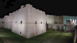
Castle of Barletta
The castle of Barletta is one of
the most important monuments of the city. It was started by the Normans and completed by Swabians, Angevins and Aragonese. It preserves the history of the city where in the past centuries the famous "Disfida" (challenge) took place.
The different dominations have left traces of their passage, in fact it was the Anjevin who transformed it from a manor into a fortress, while the Aragonese consolidated the role of defense.
Today it is a venue for exhibitions and events, and in every corner it preserves the charm of history.
Zamek Barletta
Zamek Barletta jest jednym z nich najważniejsze zabytki miasta. Zostało założone przez Normanów, a ukończone przez Szwabianów, Angevinów i Aragonese. Zachowuje historię miasta, w którym w minionych stuleciach miała miejsce słynna „Disfida” (wyzwanie).
Różne dominacje pozostawiły ślady ich przejścia, w rzeczywistości to Anjevin przekształcił go z dworu w fortecę, podczas gdy Aragończycy utrwalili rolę obrony.
Dziś jest miejscem wystaw i
wydarzeń, a na każdym rogu
zachowuje urok historii.
The cathedral of Barletta
La cattedrale di Barletta
La cattedrale di Santa Maria Maggiore è il maggior edificio di culto di Barletta, ovvero la chiesa più importante. L'edificio è diviso in due parti, quella interna in stile Romanico e quella esterna in stile gotico. L'attuale aspetto della chiesa è il risultato delle modifiche architettoniche apportate nelle diverse epoche che evidenzia una sovrapposizione di stili.
Un luogo di culto in cui la città si dedica con grande passione nel mese di Maggio, quando i fedeli seguono la messa dedicata alla Madonna dello Sterpeto.
The cathedral of Barletta
The cathedral of Santa Maria Maggiore is the most important religious building in Barletta, that is one of its most important churches.
The building is divided into two parts: the inside part is in Romanesque style and the outside part is in Gothic style.The current structure of the church derives from the architecture that changed over time because it has been built in different periods and which highlights an overlapping of styles. The people of Barletta attends the Cathedral in May, especially because of the masses dedicated to Madonna of Sterpeto.
Katedra Barletta
Katedra Santa Maria Maggiore jest najważniejszym budynkiem sakralnym w Barletcie, który jest jednym z najważniejszych kościołów. Budynek jest podzielony na dwie części: część wewnętrzna jest w stylu romańskim, a część zewnętrzna w stylu gotyckim. Obecna struktura kościoła wywodzi się z architektury, która zmieniała się w czasie, ponieważ została zbudowana w różnych okresach i która podkreśla nakładanie się stylów. Mieszkańcy Barletty uczęszczają do katedry w maju, szczególnie z powodu mszy poświęconych Madonnie ze Sterpeto.
The Cathedral by night
Eraclio
Eraclio: Barletta ospita il Colosso di Barletta, una statua in bronzo che rappresenta un imperatore romano (forse Teodosio II). Questa statua, chiamata "Eraclio" dagli abitanti di Barletta, è alta circa 4 metri e rimane la più grande statua sopravvissuta dal tardo impero romano (l'impero romano dopo Costantino). Secondo una storia popolare locale, Eraclio salvò la città da un attacco saraceno. Vedendo le navi saracene avvicinarsi alla costa di Barletta, Eraclio le aspettò sulla riva del mare. Qui Eraclio si comportava come se stesse piangendo, quindi i Saraceni gli chiesero perché fosse triste ed Eraclio rispose che era triste perché era il più piccolo tra gli abitanti di Barletta e quindi tutti lo prendevano in giro. I saraceni pensavano che gli abitanti di Barletta fossero tutti giganti, quindi lasciarono la costa, temendo di affrontarli.
Eraclio: Barletta is home to the Colossus of Barletta, a bronze statue, representing a Roman Emperor (perhaps Theodosius II). This statue, called "Eraclio" by the inhabitants of Barletta, is about 4 metres tall, and remains the biggest statue that survives from the late Roman Empire (i.e. the Roman Empire after Constantine). According to a local folk story, Eraclio saved the city from a Saracen attack. Seeing the Saracen ships approaching Barletta's coast, Eraclio waited for them on the sea shore. Here Eraclio acted as if he was crying so the Saracens asked him why he was sad and Eraclio answered that he was sad because he was the smallest among Barletta's inhabitants and so everybody made fun of him. The Saracens thought that Barletta's inhabitants were all giants, so they left the coast, fearing to face them.
Eraclio: Barletta jest domem dla Kolosa Barletty, brązowej figury przedstawiającej cesarza rzymskiego (być może Teodozjusza II). Pomnik ten, zwany przez mieszkańców Barletty „Eraclio”, ma około 4 metrów wysokości i pozostaje największym posągiem, który przetrwał pod koniec Cesarstwa Rzymskiego (tj. Imperium Rzymskiego po Konstantynie). Według lokalnej historii ludowej Eraclio uratował miasto przed atakiem Saracenów. Widząc statki Saracenów zbliżające się do wybrzeża Barletty, Eraclio czekał na nich na brzegu morza. Tutaj Eraclio zachowywał się, jakby płakał, więc Saraceni zapytali go, dlaczego jest smutny, a Eraclio odpowiedział, że jest smutny, ponieważ był najmniejszy wśród mieszkańców Barletty, więc wszyscy się z niego wyśmiewali. Saraceni myśleli, że wszyscy mieszkańcy Barletty byli gigantami, więc opuścili wybrzeże, bojąc się stawić im czoła.
Sepolcro di Barletta
Sepolcro di Barletta
La Basilica del Santo Sepolcro è una delle principali chiese di Barletta e la sua stessa titolazione ricorda il legame con la Terra Santa e il sepolcro di Gesù Cristo. La facciata d’ingresso è caratterizzata da due archi a sesto acuto disposti lateralmente e un portale d’accesso alla chiesa sovrastato da un timpano triangolare. Curiosità: nel corso della sua storia la basilica ha visto alternarsi tre campanili e ben quattro orologi.
Costruita sui resti di una preesistente basilica medioevale, l’esistenza della basilica del Santo Sepolcro è stata attestata con un certezza per merito di un documento appartenete al 1130. A questo è stata poi aggiunta una bolla di papa innocenzo secondo.
The Holy Sepulchre
The basilica of the Holy Sepulchre is one of the main churches of Barletta and its title itself recalls the bond with the Holy Land and the tomb of Jesus Christ. The entrance facade is characterized by two pointed of access to the church dominated by a triangular gable curiosity: in the course of this history the basilica has seen alternating three bell towers and four clocks .
Built on the remains of a pre-existing medieval basilica of the Holy Sepulchre has been attested with certainty thanks to apparent documents related to 1130. At this it was added a bubble of papa Innocenzo second.
Bazylika Świętego Grobowca
Bazylika Świętego Grobowca jest jednym z głównych kościołów Barletty i sam tytuł przypomina o więzi z Ziemią Świętą i grobem Jezusa Chrystusa.Fasada Wejściowa charakteryzuje się wejściem w dwóch punktach kościoła,zdominowanym przez rzadki trójkątny szczyt.w ciągu swojej historii bazylika posiadała trzy dzwony oraz cztery zegary.Została zbudowana na pozostałościach po starej średniowiecznej bazylice świętego grobowca, która została potwierdzona przez dokumenty wydane w 1130 roku.Budowa katedry została zatwierdzona Bullą papieską Innocentego ll.
Cantina
della Disfida
Barletta
La Disfida di Barletta fu uno scontro avvenuto nel 1503 nella mattina di Sant'Elia fra 13 cavalieri italiani e 13cavalieri francesi. La battaglia terminò con la vittoria degli italiani. Il 15 gennaio 1503 i prigionieri francesi furono invitati a un banchetto idealizzato da Cordova in una cantina locale (chiamata oggi Cantina della Disfida). Durante il banchetto il capo francese accusò gli italiani di codardia. A causa di ciò si decise di disputare uno scontro: il capo francese decise che si sfidassero 13 cavalieri per parte il 13 febbraio 1503 tra Andria e Corato. Jean D'Autor afferma che gli italiani invece di avanzare arretrarono fino al limite del campo formando un cerchio. La battaglia continuò finchè tutti i francesi non vennero catturati e uccisi.
The challenge of Barletta was a clash started in the morning of Saint Elia in 1503 between 13 Italian knights and 13 French knights. The challenge finished with a victory of Italians. On 15 January 1503, French prisoners were invited to a banquet organized by Consaldo da Cordova on the local cave (nowadays called The Cave of the Challenge of Barletta). During the banquet the French chief accused the Italians of cowardice. Because of this, it was decided to wrangle a clash. The French chief decided that 13 of his knights would challenge 13 Italian knights on February 13, 1503, between Andria and Corato. Jean D'Autor claims that the Italians instead of advancing retreated backwards to the end of a field, forming a circle. The challenge continued until all the French were captured and killed.
Wyzwanie Barllety było starciem św. Elii rano w 1503r. Między 13 włoskimi rycerzami i 13 francuskimi rycerzami . Wyzwanie zakończyło się zwycięstwem Włochów. 15 stycznia 1503r. Francuscy zostali zaproszeni na bankiet zorganizowany przez Consaldo da Cordova w miejscowej jaskini (obecnie o nazwie The Cave the Challenge of Barletta). Podczas bankietu francuski szef postanowił, że 13 jego rycerzy rzuci wyzwanie 13 włoskim rycerzom 13 lutego 1503r. Między Andrią a Corato. Jean D'Autor stwierdził, że Włosi zamiast posuwać się wycofali do końca pola tworząc okrąg. Wyzwanie trwało dopóki wszyscy Francuzi nie zostali schwytani i zabici.
Canne della battaglia
CANNE DELLA BATTAGLIA
Canne era un'antica città della Puglia. Celebre per la famosa Battaglia di Canne, oggi nella località chiamata Canne della Battaglia, si possono trovare resti archeologici di grande interesse. Nei dintorni sono stati ritrovati i resti di un villaggio apulo e quelli di una necropoli.
La battaglia di Canne è stata una delle principali battaglie della seconda guerra punica. È stata, in termini di caduti in combattimento, una delle più pesanti sconfitte subite da Roma ad opera dei
Cartaginesi, guidati dal condottiero Annibale,
ed è considerata come una delle più grandi
manovre tattiche della storia militare.
THE BATTLE OF CANNE
Canne was an ancient city in Puglia. Famous for the famous Battle of Canne, today in the locality called Canne della Battaglia, you can find archaeological remains of great interest. In the surroundings, the remains of an Apulian village and those of a necropolis have been found. The Battle of Canne was one of the main battles of the Second Punic War. It was, in terms of casualties in combat, one of the heaviest defeats suffered by Rome by the Carthaginians, led
by the leader Annibale, and is considered
to be one of the largest tactical maneuvers
in military history.
CANNE DELLA BATTAGLIA
Kanny były starożytnym miastem w Puglii. Słynne z bitwy pod Kannami, dziś w okolicy nazywanej Canne della Bataglia można zobaczyć bardzo ciekawe znaleziska archeologiczne. W okolicy odnaleziono resztki wioski apulijskiej i nekropolii.
Bitwa pod Kannami była jedną z głównych bitew drugiej wojny punickiej. Pod względem liczby ofiar była jedną z najcięższych porażek zadanych Rzymianom przez wojska Kartaginy, dowodzone przez Hannibala, i jest uwazana za jeden z największych
manewrów taktycznych historii wojskowości.
Litoranea di Ponente
Litoranea di Ponente e levante
La costa barlettana, complessivamente estesa dai confini territoriali con i comuni di trani e Margherita di Savoia per circa 13 Km, è divisa in due tratti che prendono il nome di litoranea di ponente, ad ovest, e litoranea di levante, ad est, dalla loro collocazione rispetto al Porto che le separa. Il fronte-mare risulta essere quasi interamente sabbioso tranne che in prossimità dell'estremo levante, dove la sua conformazione assume carattere roccioso,
progressivamente artificiale
prima e naturale poi.
La litoranea di ponente
offre opportunità agli a
ppassionati di pesca e surf.
Ponente and Levante coast
The coast in Barletta, stretches from the district of Trani and Margherita di Savoia for about 13 km, and it is divided into two parts called Ponente (in the west) and Levante (in the east). Both parts are separated by a port.
The coast is sandy except for the far eastern part, consisting of artificial and
natural rocks.
Ponente is great
for fishing and
surfing.
Litoranea di Ponente e levante
Wybrzeże Ponente i Levante.
Wybrzeże w Barletcie, ciągnie się od dzielnicy Trani i Margherita di Savoia przez około 13 km, i dzieli się na dwie części nazywane Ponente (na zachodzie) i Levante (na wschodzie). Obie częsci rozdzielone są portem.
Wybrzeze jest piaszczyste z wyjątkiem dalekiej części wschodniej, złożonej ze sztucznych i
naturalnych skał. Ponente sprzyja
łowieniu ryb i surfowaniu.
(na zdjęciu palmy w Ponente)
POLAND SULĘCIN
Jeziora i lasy w naszej okolicy
(Żubrów, Lubniewice)
Jeziora i lasy w naszej okolicy
The lakes and forests in our district
Lubniewice i Żubrów są położone w okolicach
Sulęcina w wojewódzwie Lubuskim, które jest
najbardziej zalesionym województwem w
Polsce. Lasy są częstymi celami naszych
spacerów, wycieczek rowerowych, a także zielonymi miejscami,
w których możemy odpocząć, a zarazem uzbierać grzyby, które napotkamy na swojej drodze. W jednym z lasów w Żubrowie znajduje się uroczysko, które jest punktem częstych spotkań i imprez.
Nad jeziora wybieramy się głównie w lato- popływać lub spędzić czas ze znajomymi opalając się na plaży.
Mimo tłumów ludzi, które tam przyjeżdżają,
dzięki pięknym krajobrazom jest to jedno z
naszych ulubionych miejsc wypocznku.
Lubniewice and Żubrów are located near Sulęcin in Lubuskie voivodeship, which is the most forested voivodship in Poland. Forests are often the targets of our walks, bike trips and as well as green places where we can relax and collect mushrooms that we'll encounter on our way.
In one of the forests in Żubrów is ,,uroczysko", that is the point of frequent meetings and events.
We go to the lakes mainly in the summer- swim or spend time with friends sunbathing on the beach.
Despite the crowds of people, who come
there, thanks to the beautiful landscapes
it is one of our favorite places to rest.
Lubniewice e Zubrow si trovano vicino Sulecin nel voivodato di Lubuskie, che è il voivodato più boscoso della Polonia. Le foreste sono spesso l'obiettivo delle nostre camminate, gite in bici e, luoghi verdi dove possiamo rilassarci e raccogliere funghi che troveremo lungo la strada.
In una delle foreste di Zubrow, c'è uroczysko, un punto di incontri o eventi frequenti.
Passiamo ai laghi; principalmente in estate, nuotiamo o passiamo il tempo con gli amici a prendere il sole sulla spiaggia. Nonostante le numerose persone che vengono per gli splendidi paesaggi, è uno dei nostri posti preferiti per riposare.
Międzyrzecki Rejon umocniony
System fortyfikacji stworzony przez Niemców w latch 1934-1944 znajdyjący się na ziemi Lubuskiej, niedaleko Międyrzecza. MRU jest jedynym z największych podziemnych systemów fotyfikscyjnych na świecie. Jego centralna część to także rezerwat nietoperzy, w którym przebywa ponad 30 tys. osobników z 12 gatunków nietoperzy. Cała długość
podzimnych korytarzy
szacowana jest na ok.
32-35km.

Międzyrzecki Rejon Umocniony (Ostwall)
System of fortyfications created by the Germans in 1934-1944 to protect the eastern boreder of the Reich. Located in the Lubuskie Province, near Międzyrzecz.
MRU (Ostwall) is one of the largest underground fortification systems in the world. Its central part is also a bat reserve, hausing over 30 thausand inviduans of 12 species of bats.The total lenght of underground corridors is estimated at at about 32-35 km.
Międzyrzecki Rejon Umocniony (Ostwall)
Sistema delle fortificazioni create dai tedeschi nel 1934-1944 per proteggere il Boreder orientale del Reich. Situato nella provincia di Lubuskie, vicino a Międzyrzecz.MRU (Ostwall) è uno dei più grandi sistemi di fortificazione sotterranea al mondo. La sua parte centrale è anche una riserva di pipistrelli, che ospita oltre 30 thaus e inviduani di 12 specie di pipistrelli. La lunghezza totale dei corridoi sotterranei è stimata in circa 32-35 km.
Ujscie Warty
,,Ujście Warty" National Park"
The National Park was founded in 2001 and is the youngest Polish national park. The park is located in a place where two rivers of Oder and Warta are connected. The symbol of this park is a goose. At the time of the flight, the great number of these birds sleeps in this park. This park is the stronghold of the birds. Some live here all year, some fly to bear eggs and raise their young, others stop here on their way to warm countries. There are a number of valuable plant communities in the park that are characteristic of river valleys. The landscape dominates vast and submerged meadows and pastures. The vegetation of the marsh vegetation is dominated by turbombers. There is also a valuable oak tree in the breeding habitat. However, forests cover only a few percent of the park's surface. The area is a place of rest and solidification, as well as the multiplication of rare and endangered animals, such as: The European beaver, Mergus,Bucephala,Ardea,Ciconia,Martes
Parco Nazionale
Il Parco Nazionale è stato fondato nel 2001 ed è il più giovane parco nazionale polacco. Il parco è situato in un luogo dove sono collegati due fiumi Oder e Warta. Il simbolo del parco è un'oca. Durante il volo, gran parte di questi uccelli dormono in questi parco. Questo parco è la fortezza degli uccelli. Alcuni vivono qui tutto l'anno, altri volano per deporre le uova e crescere i loro piccoli, altri si fermano qui sulla loro strada per i paesi caldi. C'è un prezioso numero di piante nel parco che sono caratteristiche delle valli fluviali. Il paesaggio dominato è vasto e sommerso da prati e pascoli. La vegetazione è dominata da turbombers. C'è anche una quercia pregiata. Però, le forste ricoprono solo una piccola percentuale della superficie del parco. L'area è un posto di riposo e consolidazione, così come la presenza di molteplici animali rari in via di estinzione, ad esempio, il castoro europeo, il Mergus, il Bucephala,l'Ardea, Ciconia , Martes
Kostrzyn Fortress
The Kostrzyn Fortress is a fortification complex built and used between the 15th and 20th centuries in Kostrzyn on the Oder River and nearby area. The first fortifications in that place was the castle. In the second half of the 16th century, the city was surrounded by fortifications designed on an Italian model, which partly survived to this day. The fortress was gradually expanded over the next centuries. Currently, the area of the fortress is divided by the Polish-German border.
Twierdza Kostrzyn
Twierdza Kostrzyn to kompleks fortyfikacyjny zbudowany i wykorzystywany w XV i XX wieku w Kostrzynie nad Odrą i okolicach. Pierwszymi fortyfikacjami w tym miejscu był zamek. W drugiej połowie XVI wieku miasto było otoczone fortyfikacjami zaprojektowanymi na wzór włoski, który częściowo zachował się do dziś.
Twierdza była stopniowo rozbudowywana w ciągu następnych stuleci. Obecnie obszar twierdzy jest podzielony granicą polsko-niemiecką.
La fortezza di Kostrzyn è un complesso di fortificazioni costruito e utilizzato tra il XV e il XX secolo a Kostrzyn sul fiume Oder e nelle vicinanze. Le prime fortificazioni in quel luogo furono il castello. Nella seconda metà del XVI secolo, la città fu circondata da fortificazioni progettate su un modello italiano, che sopravvisse in parte fino ai giorni nostri. La fortezza fu gradualmente ampliata nei secoli successivi. Attualmente, l'area della fortezza è divisa dal confine polacco-tedesco.
La fortezza di Kostrzyn
A tour of Sulęcin
Witajcie na wycieczce w Sulęcinie!
Oprowadzimy Was po naszym mieście. Sulęcin jest miastem leżącym w zachodniej części Polski. Jest to mała miejscowość, która liczy około 10 500 mieszkańców. Teraz zapraszamy na krótką wirtualną wycieczkę. W okolicach Sulęcina znajduje się kilka jezior, na przykład Ostrowskie oraz Wędrzyńskie. W naszym powiecie znajdują się piękne lasy. Mamy dużo ścieżek rowerowych i co roku organizujemy zjazdy cyklistów, które cieszą się wielkim zainteresowaniem.
Welcome to the trip to Sulęcin!
We will guide you around our city. Sulęcin is a city located in the western part of Poland. It's a small town with a 10 500 inhabitants. Now we invite you for our virtual tour. There are several lakes around Sulęcin, for example Ostrowskie and Wędrzyńskie. There are beautiful forests in our poviat. We have a lot of bicycle paths and every year we organize congress of cyclists who enjoy great interest.
Benvenuti alla nostra gita di Sulecin!
Vi guideremo nella nostra città. Sulecin è una città situata nella parte occidentale della Polonia. E' una piccola città con 10500 abitanti. Adesso vi invitiamo al nostro tour virtuale.
Diversi laghi circondano Sulecin, per esempio Ostrowskie e Wedrzynskie. Nei distretti della nostra città possiamo trovare delle belle foreste.
Abbiamo diverse piste ciclabili e ogni anno organizziamo congressi di ciclisti che dimostrano grande interesse.
Parki
W Sulęcinie znajdują się parki. Można na ich terenie spędzić miło czas, spotkać się z przyjaciółmi, pojeździć na skateparku. Dzieci mogą spędzić czas na placu zabaw, a dorośli w tym czasie mogą odpocząć na świeżym powietrzu.
Parks
There are parks in Sulęcin you can spend a nice time on them, meet friends, ride a skatepark. Children can spend time on play ground and adults at this time can relax outdoors.
Parchi
Ci sono parchi a Sulecin dove puoi passare dei bei momenti,incontrare amici,andare sullo skate. I bambini possono passare del tempo nei parco giochi e gli adulti in quel momento possono rilassarsi all'aperto.
"Kormoran"
Hotel "Kormoran Resort & SPA" położony jest na obrzeżach miasta Sulęcin, 2,5 km od jego centrum. Na obszarze 80 hektarówpośród akwenów wodnych pobliskiej rzeki Postomii, mieszanych lasów, zieleni i ciszy można znależć spokój do wypoczynku i relaksu.
"The Kormoran"
The hotel "Kormoran Resort & SPA" is located on the outskirts of the city od Sulęcin, 2,5 kilometers from its center. On an area of 80 hectares, among water reservoirs, the nearby Postomia river, mixed forests, greenery and quietness, find peca for rest and relaxation.
"Il Kormoran"
L'hotel "Kormoran Resort & SPA" è localizzato nella periferia della città di Sulecin, 2,5 kilometri dal centro. Su un'area di 80 ettari,tra i bacini idrici,il vicino fiume Postomia,foreste miste,vegetazione e tranquillità,una peca per riposarsi e rilassarsi.
- < BEGINNING
- END >
-
DOWNLOAD
-
LIKE(1)
-
COMMENT()
-
SHARE
-
BUY THIS BOOK
(from $10.79+) -
BUY THIS BOOK
(from $10.79+) - DOWNLOAD
- LIKE (1)
- COMMENT ()
- SHARE
- Report
-
BUY
-
LIKE(1)
-
COMMENT()
-
SHARE
- Excessive Violence
- Harassment
- Offensive Pictures
- Spelling & Grammar Errors
- Unfinished
- Other Problem





COMMENTS
Click 'X' to report any negative comments. Thanks!